Media Manager
Namespaces
Choose namespace


Media Files
Files in web

- donautal_additional_waypoints.png
- 1528×724
- 2017/04/27 02:24
- 457 KB

- donautal_first_import.png
- 1526×760
- 2017/04/27 02:09
- 471.9 KB

- donautal_move_waypoint.png
- 515×572
- 2017/04/27 02:46
- 38.1 KB

- donautal_snap_waypoints.png
- 273×50
- 2017/04/27 02:34
- 5.6 KB

- roadbook_kurviger_excel_beispiel_komplett.jpg
- 646×421
- 2017/07/10 15:45
- 74.4 KB

- roadbook_kurviger_excel_beispiel_legende.png
- 778×329
- 2017/07/10 16:09
- 15.8 KB

- roadbook_kurviger_excel_beispiel_nur-pausen.jpg
- 646×256
- 2017/07/10 15:45
- 38.5 KB

- roadbook_kurviger_excel_beispiel_wegpunkte.jpg
- 647×431
- 2017/07/10 15:48
- 62.7 KB

- route-options-per-leg-map.png
- 248×201
- 2020/12/24 10:25
- 34.5 KB

- route-options-per-leg-overview.png
- 822×926
- 2020/12/24 10:25
- 1.2 MB

- route-options-per-leg-sidebar.png
- 318×294
- 2020/12/24 10:25
- 28.2 KB

- snap_2017.07.05_22h16m02s_001.png
- 1303×872
- 2017/07/07 10:41
- 136.4 KB

- snap_2017.07.05_22h16m17s_002.png
- 605×399
- 2017/07/07 10:41
- 25.8 KB

- snap_2017.07.07_21h31m47s_003.png
- 1345×909
- 2017/07/09 10:06
- 1.9 MB

- snap_2017.07.07_21h34m21s_005.png
- 951×412
- 2017/07/09 10:06
- 41.6 KB

- snap-waypoints-v2.png
- 316×42
- 2019/10/31 09:51
- 5.6 KB

- snap-waypoints.png
- 316×42
- 2019/10/31 09:50
- 5.6 KB

- web-avoidances_v3.png
- 794×1242
- 2023/10/11 14:17
- 161.1 KB

- web-avoidances.png
- 796×1234
- 2021/07/11 15:21
- 157.9 KB

- web-curvature-buttons.png
- 780×102
- 2021/07/12 09:46
- 11.6 KB

- web-curvatureall-alternatives_v2.png
- 1542×732
- 2023/10/11 14:30
- 2.3 MB

- web-curvatureall-alternatives.png
- 1640×382
- 2020/11/21 16:29
- 722.3 KB

- web-curvatureall-waypoint-set_v2.png
- 1544×772
- 2023/10/11 14:30
- 2.4 MB

- web-curvatureall-waypoint-set.png
- 1340×322
- 2020/11/21 16:30
- 577.7 KB

- web-name-waypoint.png
- 804×1274
- 2021/07/11 15:18
- 154 KB

- web-poi-info-window.png
- 506×670
- 2020/11/20 16:05
- 408.8 KB

- web-poi-map.png
- 690×350
- 2021/07/11 15:25
- 389.6 KB

- web-poi-window.png
- 798×1138
- 2021/07/11 15:32
- 784.6 KB

- web-route-details_v2.png
- 778×64
- 2023/10/11 14:09
- 16.3 KB

- web-route-details-1.png
- 1072×458
- 2020/11/21 16:13
- 228.8 KB

- web-route-details-2_v2.png
- 790×1486
- 2023/10/11 14:06
- 194.1 KB

- web-route-details-2.png
- 312×167
- 2020/11/21 16:13
- 12.1 KB

- web-route-details-3_v2.png
- 1778×374
- 2023/10/11 14:04
- 785.9 KB

- web-route-details-3.png
- 2153×196
- 2020/11/21 16:13
- 166.7 KB

- web-route-details-4.png
- 458×489
- 2020/11/21 16:13
- 83.3 KB

- web-route-details-speed_v2.pn.png
- 2436×1226
- 2023/10/11 14:21
- 4.1 MB

- web-route-details-speed.png
- 2109×1157
- 2020/11/21 16:14
- 1.3 MB

- web-sample-route.png
- 1669×392
- 2020/11/20 09:35
- 544.4 KB


![[root]](/web/faq/export_to_garmin?ns=&tab_files=files&do=media&tab_details=view&image=app%3Afaq%3Adistance_on_map.png)
File
- Date:
- 2018/06/14 09:50
- Filename:
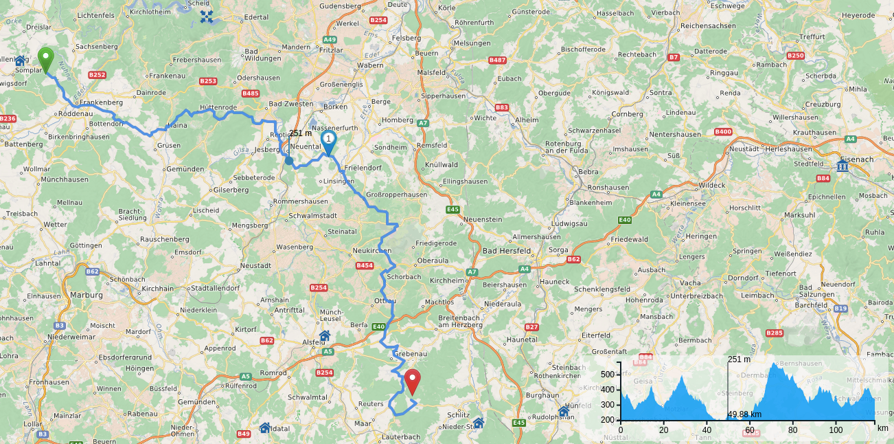
- distance_on_map.png
- Format:
- PNG
- Size:
- 1MB
- Width:
- 1302
- Height:
- 646